Indonesia
Warnings and insurance
The Foreign, Commonwealth & Development Office (FCDO) provides advice about risks of travel to support British nationals in making informed decisions. Find out more about FCDO travel advice.
Areas where the FCDO advises against travel
Your travel insurance could be invalidated if you travel against FCDO advice. Consular support is also severely limited where FCDO advises against travel.
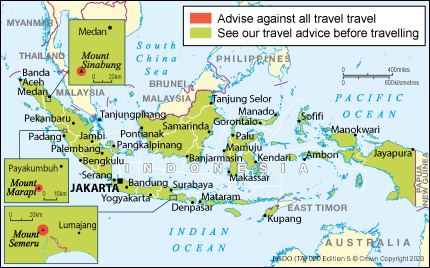
Mount Marapi, Western Sumatra
FCDO advises against all travel to within 3km of the crater of Mount Marapi in West Sumatra.
Mount Sinabung area, Karo Regency
FCDO advises against all travel within 5 km of the Mount Sinabung crater in Karo Regency, North Sumatra.
Mount Semeru area, Lumajang Regency
FCDO advises against all travel within 5 km of the crater of Mount Semeru in Lumajang Regency, East Java. FCDO also advises against all travel to the southeast area of Mount Semeru along the Besuk Kobokan river (approximately 13 km from the crater). You should stay at least 500 m from the Besuk Kobokan riverbank.
Find out more about why FCDO advises against travel
Before you travel
No travel can be guaranteed safe. Read all the advice in this guide as well as support for British nationals abroad which includes:
- advice on preparing for travel abroad and reducing risks
- information for women, LGBT and disabled travellers
Follow and contact FCDO travel on Twitter, Facebook and Instagram. You can also sign up to get email notifications when this advice is updated.
Travel insurance
If you choose to travel, research your destinations and get appropriate travel insurance. Insurance should cover your itinerary, planned activities and potential expenses in an emergency.